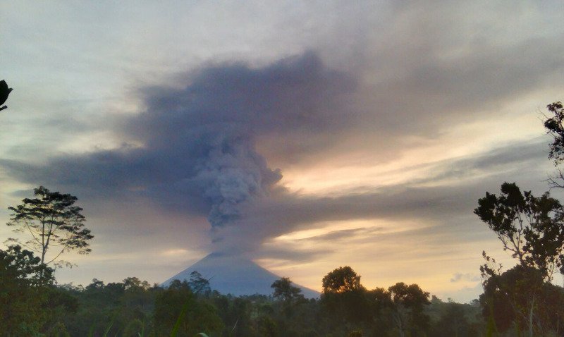
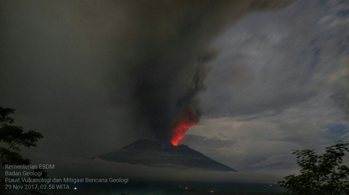
#Agung experienced inflation before the phreatic eruption of November 21, 2017 and inflation is also still recorded by a tiltmeter installed 4 km from the peak of Agung in the South. This indicates sufficiently strong pressure towards the surface.
Measurements of gas after the phreatic eruption on November 21, 2017 show that magmatic gases like C02 and S02 are consistently observed. This indicates that the pathway for the magma has opened so that gases can come out more easily.
Based on the analysis of visual and instrumental data of G. Agung activity, it can be concluded that the volcanic activity of G. Agung is currently at a very high level so that the probability of a bigger eruption is increasing.
It should be understood that eruption intensity cannot be predicted. Estimating the future character of the Agung eruption is more difficult than other volcanoes because of the absence of instrumental data from previous eruptions for comparison
The only data that can be used as a guideline is the phenomena of the sequence of Earthquakes felt by the people around Agung in 1963 that were also felt this year.
Preparation efforts must be carried out.
**Potential Hazards** 1. The eruption history of Agung is characterized by explosive and effusive eruptions, with the activity occurring in the current Crater
2. Based on its history, if there is an eruption like 1963, then the potential hazards that may occur can be pyroclastic flows, ashfall, lava flows, and lahars. If a similar eruption occurs, the potential danger within a 8 km radius is also tephra (large ash) fall =/>6 cm.
4. The result of modeling the potential for the distribution of ashfall indicates that if the current eruption occurs with the assumption of explosive eruption index of VEI Ill then the W, NW and N sectors of G. Agung are the most threatened sectors...
...The sector can be potentially hit by heavy ashfall with a maximum thickness of 1.6 meters (up to 15 km from the summit of Mount Agung) and maximum thickness of 0.4 meters (up to 30 km from the Agung Peak).
4. The results of the potential model of volcanic ash distribution in the air indicate that volcanic ash can be spread far from Agung and is expected to disrupt flight operations to and from: Bali, Lombok, Surabaya and Banyuwangi...
...However, the potential for volcanic ash disturbance is very much dependent on wind direction and speed, so that the parties concerned with aviation safety are expected to be adaptive in accordance with actual conditions.
5. The result of modeling the potential of pyroclastic flows under the assumption of eruption volume of 5 million m3, the pyroclastic flows could potentially travel to the N-NE, SE & S-SW sectors with a range of about 10 km in less than 3 minutes...
...However, if the eruption volume exceeds 10 million m3, then pyroclastic flows can potentially travel to the N-NE, SE,
and S-SW beyond 10 km. Therefore, in the future PVMBG will change the recommendations in accordance with the latest monitoring data developments.
6. - [!Unsure of this translation speaks of dangers in] 'Tuluken Tukad Tulung, Tukad Daya, Tukad Celagi which is at the crater opening area, in the SE especially in the watershed Tukad Bumbung, and in South-West sector especially in Pati, Tukad Panglan, and Tukad Jabah areas'
**Conclusions** 1. To date, based on data observed and analyzed comprehensively by PVMBG, the Agung activity is inferred to indicate an increasing trend.
2. If a large eruption occurs, there is considerable disaster potential because today many people live in disaster prone areas. In addition, people around Agung do not have the experience to face the eruption because this volcano last erupted in 1963 (54 yrs ago).
3. Based on the result of visual and instrumental data analysis as well as considering the potential of danger threats, starting from 27 November 2017 at 06.00 WITA the status of Gunungapi Agung is raised from Level Ill (Alert) level IV (Awas) .
***Recommendations***
ALL Must evacuate areas inside the Agung crater and in all areas within a radius of 8 km from the Crater, and added sectoral expansion to North-Northeast and Southeast-South-Southwest as far as 10 km from the Agung Crater.
These zones are dynamic and sucbejct to change with up ongoing observational data. Areas affected include Ban Village, Dukuh, Baturinggit, Sukadana, Kubu, Tulamben, Datah, Nawakerti, Pidpid, Buanagiri, Bebandem, Jungutan, North Duda, Amerta Buana, Sebudi, Besakih & Pempatan.
2. If a larger eruption occurs then another potential danger is the occurrence of heavy ashfall over the entire Estimated Danger Zone. Heavy ashfall can also extend its impact beyond the Estimated Danger Zone depending on the direction and speed of the wind.
At the time of this recommendation, the wind blows predominantly towards the East-Southeast.
3. Given the potential dangers of volcanic ash causing acute respiratory distress (ISPA) in humans it is expected that all communities, primarily living around Agung and on the island of Bali, immediately prepare a mask cover the nose and mouth and eye protection.
4. Given that volcanic ash now falling in some sectors around G. Agung, coupled with relatively high rainfall, the people who live around the rivers flowing near Agung need to be aware of the potential threat of lahars...
... If lahars flow with high intensity they endanger safety, people can temporarily stay away in safer places until conditions allow them to return.
5. Local Government and its staff + BNPB work to establishing communication networks through cellular phone (WhatsApp Group) and integrated radio communication to overcome the limitations of cell phone signal around Agung...
...It is expected that a routine and fast information dissemination process can be well organized.
6. All stakeholders in the aviation sector continue to follow Agung's development routinely, because observation data can rapidly change, so that preventive efforts to ensure air safety can be done
7. All parties to maintain a calm atmosphere on the island of Bali, do not spread false news (hoax) and not spread information about the eruption of Agung if the source is not clear.
8. Center for Volcanology and Geological Hazard Mitigation, Geological Agency continues to coordinate with Local Government, BNPB, BPBD Bali Province and BPBD Kabupaten Karangasem in providing information about the activities of G. Agung.
9. Communities around Agung & climbers/visitors/travelers are expected to remain calm while maintaining vigilance and following advice of Regional Government, Regency/City Government, Provincial/ Regency/City BPBD and other related apparatus...
...in accordance with recommendations issued by the Center for Volcanology and Mitigation Geological Disasters, Geology Division so that if required, rapid strategic mitigation efforts can be done immediately and without waiting for a long time.
10. Official changes in Agung status can be accessed at magma.vsi.esdm.go.id or through the Android MAGMA Indonesia app that can be downloaded in Google Play. Stakeholders in the aviation sector can access the VONA (Volcano Observatory Notice for Aviation) feature.
Data Source:
Center for Volcanology and Geological Hazard Mitigation of Geological
Agency of the
Ministry of Energy and Mineral Resources
- END
For important Hazards and Impacts from Lahars and Pyroclastic flows, in several languages, please refer to these VolFilm videos: vimeo.com/volfilm/videos
• • •
Missing some Tweet in this thread? You can try to
force a refresh
1/n * Monitoring Data Analysis *
-Visual-
After undergoing a volcanic earthquake swarm over the period Sept-Oct 2017, finally on 21 November 2017 at 17:05 WITA the phase of eruption of Mount Agung evolved to produce volcanic ash as high as 700 m above the peak.
2/n After the eruption, the next eruption occurred again on November 25, 2017 at 17:20 WITA with an ash plume height of 1500 m above the peak. On 26 and 27 November 2017 eruptions occurred with the ash column height reaching 3000 m above the peak.
Incandescence from lava is visible in the crater at night. Tremor is continuous. Alert level remains at IV, the highest level.
PVMBG continues to record increasing volcanic activity. The potential for a larger eruption is increasing.
However, the intensity and timing cannot be predicted with certainty. Estimating the future character of the eruption of Agung tends to be more difficult than other volcanoes due to the absence of instrumental data from previous eruptions for comparison.